PlanetSKI Snow Report
30th December 2021
Last modified on January 4th, 2022
The warm weather in the Alps is finally set to change with a cold front approaching from the North. It is bringing some snow. In North America after record snowfalls and plunging temperatures the sun is finally making an appearance. UPDATED
Update:
A return to winter is on the way after some historic high alpine temperatures in recent days over New Year.
It will be very welcome.
The warm weather from the south is set to be replaced by cold weather from the north.
The change should start late on Tuesday – we’ll keep you posted.
We have detailed the unseasonable warm weather earlier and lower down this PlanetSKI rolling blog.
The impact of the warm temperatures on the snowpack across the Alps is perhaps not as bad as some may think.
“Although the exceptionally mild temperatures of recent days have led to a rapid thaw and deterioration of snow conditions at lower altitudes, this has been far from disastrous for a couple of reasons,” said the alpine weather expert, Fraser Wilkin, from weathertoski.co.uk
“Firstly, there was already a lot of snow across much of the Alps, and secondly, the sun is still very weak at this time of year, meaning that it has not compounded the thaw as it would later in the season.”
“So, although snow depths have taken quite a hit below 2000m or so, most lower resorts are still comfortably skiable down to village level.”
Check out some further New Year images, videos and wishes from the Alps:
Toute l’équipe d’#IsereAttractivite vous souhaite une bonne année 2022 ! pic.twitter.com/d4WmglCv1r
— Isère Attractivité (@alpes_ishere) January 3, 2022
Saturday 1st January
It is one of the warmest New Year holidays on record with the freezing levels up to 3,700m in parts of the French Alps.
It is +10c at 2,000m in parts of the Swiss Alps.
Not good for the snowpack.
There is also risk of avalanche after all the rain.
In parts of Switzerland the avalanche danger is ‘considerable’ – Level Three on a scale of 5.
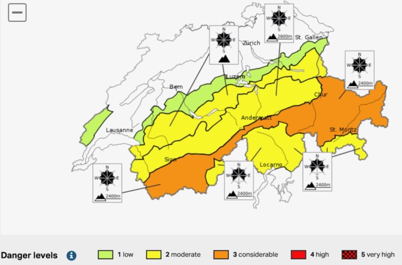
Image c/o Swiss Institute for Snow & Avalanche Research
Here is the latest from the Swiss Institute for Snow & Avalanche Research, on Saturday 1st January 2020:
The snowpack shows striking effects of rainfall and wind from this last week.
It is thoroughly wet up to high altitudes.
At very least the uppermost layers of the snowpack are moist on the northern flank of the Alps up to approximately 3000 m, and in southern regions up to approximately 2600 m; at higher altitudes these layers are dry.
During nights of clear skies a crust forms on the surface which is often breakable, i.e. not capable of bearing loads.
The crusts subsequently soften up during the course of the day on steep sunny slopes.
The warm weather has been caused by the winds coming from the south and south west tha is bringing very warm air from the Azores nearly all the way from the tropics.
It is expected be a bit colder on Sunday and then all change on Tuesday as the southerly winds are replaced by northerly winds that will bring colder temperatures.
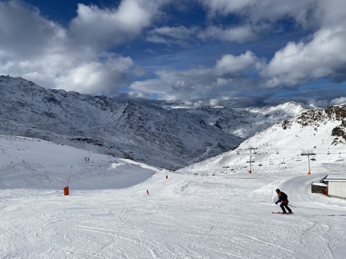
Val Thorens, France. Image © PlanetSKI
For those lucky enough to be in the mountains the snow is heavy and melting fast, but they are pleased to be out on snow and looking forward to better times in 2020.
Bonne Année / Happy New Year to all lovers of the French Mountains. We hope for a 2022 with open resorts & free travel for all! #FrenchMountainsNaturally 📸 @manigodofficiel pic.twitter.com/09iqMrfNWY
— French Mountains (@FrenchMountains) January 1, 2022
Meanwhile over in the USA it’s been rather snowy in California over the New Year holidays…
DEEPcember is out to play at @palisadestahoe. After receiving 9+ feet of snow since Wednesday and over 16.5 feet throughout the month, it is officially the snowiest December on record. 🥶❄️ pic.twitter.com/TqY5bSYVu4
— Ikon Pass (@IkonPass) December 30, 2021
And while we are looking at snow conditions across the world….
Friday 31st December
“There were still some showers (snow 2300m) across the northern and north-eastern Austrian Alps, otherwise elsewhere in the Alps it is generally quite sunny and very warm, with freezing levels as high as 3700m in the southern French Alps,” said the alpine weather expert, Fraser Wilkin of Weathertoski.
“Friday and Saturday will be mostly sunny right across the Alps, with exceptionally high, potentially record-breaking temperatures in some south-western regions.
“In the southern French Alps, for example, freezing levels could reach 3800m with maximum temperatures of 15°C at 1500m.”
https://www.facebook.com/weathertoski/posts/2060985697390916
Thursday 30th December
It’s unseasonably mild and rainy across much of Europe.
It’s a generally unsettled picture in the Alps.
While the highest resorts have had as much as half a metre of snow in the last 48 hours, the freezing level – in some places at 2,500 metres or above – means the precipitation has turned to rain.
Where heavy snow has fallen, the risk of avalanche is very high.
Well that’s not good…a super saturated snowpack below 3000 metres is causing widespread full depth wet slab avalanches in the Western Alps, especially where the snowpack is laying on grass. This size 2 ran naturally across the piste at 8:30 this morning in St Gervais. pic.twitter.com/5wdHIPO4Uh
— avalanche geeks (@AvalancheGeeks) December 30, 2021
https://www.facebook.com/valdisere/posts/10159016922673096
World Cup ski racing has become a casualty of the weather.
The Men’s Super-G scheduled to take place in Bormio in Italy today has been called off.
“Due to the warm weather present, in the interest of safety, the Jury together with the OC have decided to cancel todays men’s super-G at the Bormio FIS Ski World Cup,” the International Ski Federation announced on Facebook.
The Chief Race Director for mens’ World Cup, Markus Waldner, has been explaining the decision:
https://www.facebook.com/fisalpine/videos/963541927879500/
The women’s World Cup giant slalom and slalom races on 8th and 9th January at Maribor in Slovenia have also been called off.
“Due to the present situation on the race hill and unfavourable weather forecast the women’s Audi FIS Ski World Cup races in Maribor (SLO) scheduled on the 8th-9th January 2022 have been cancelled. A possible replacement will be communicated in due course,” FIS has said in a statement.
In North America, things are looking up for the New Year holiday.
It looks as if the record-breaking snowstorms which blocked roads, cut off ski areas and brought down power lines, are easing.
Sunshine is forecast.
There should be some spectacular deep powder conditions.
Back in November some ski resorts in parts of the Rockies and the Sierra Nevada were unable to open because there was not enough snow.
Earlier this week, they had to shut due to too much snow.
The Tahoe area has had more than 5 metres of snow since the beginning of December, according to the UC Berkeley Central Sierra Snow Laboratory.
That makes it the third snowiest month since the lab started tracking snowfall in 1970 and the snowiest December ever.
https://www.facebook.com/palisadestahoe/posts/10159741807299044
“We are finally experiencing a true break in the weather after an additional 4 inches of snow overnight,” Palisades resort in Tahoe said on Wednesday.
“One item of note is that the upcoming temperatures for the week are going to be very cold.
“These forecasted temperatures are our lowest in 5 years for this time of year, so bundle up!
“As we look ahead into this weekend, we expect a high skier turnout and clear, sunny skies for Friday, Saturday, and most of Sunday. Another weather pattern moves in on Monday.”
At Northstar in California, the search will resume later today for a 43-year-old skier who has not been seen going skiing on since Christmas Day.
Rory Angelotta was reported missing when he failed to turn up for dinner with friends.
Northstar was closed on Monday because of blizzard conditions.
Almost 2 metres of snow fell on the resort in 48 hours.
It’s not just California.
There has been heavy snow in Utah too, with more than 2 metres this month.
“We have received 84” of snow in December and our Mountain Operations team is working hard to get the rest of the resort open as soon as possible,” Deer Valley posted on Wednesday 29th.
https://www.facebook.com/SkiDeerValley/videos/1290185661504581/
Over the border in Canada, the exceptionally cold weather continues.
Sunshine Village, Alberta, took the decision to close on Sunday when temperatures plummeted to -30 degrees Celsius.
It’s warmed up – a bit – since and re-opened.
Thursday is forecast to be a ‘balmy’ -21c.

