Extreme Caution Urged As More Snow Falls on Unstable Base
28th January 2021
Last modified on May 20th, 2021
In Switzerland and parts of France the avalanche risk is now Level 5 – ‘Very High’. The snowpack is ‘extremely unstable’ and the risk will be ‘critical’ in places by Friday. Already in Switzerland this winter 16 people have died in avalanches. There have been further fatalities and avalanches in France. UPDATED
UPDATED:
The avalanche danger level has been raised to Level 5 in some parts of the Alps as the snow continues to fall.
It is the highest level on the scale.
A walker was buried under 2.5m of snow in Val d’Isere in France, but was rescued alive as the man was caught in an air pocket.
He was buried for two hours and 40 minutes.
The rescue services have described it as a “miracle”.
“Thanks to the mobilization of nearly 100 people: gendarmes of the PGHM and the mountain group of the Albertville company, ski patrollers, guides, ski instructors and firefighters, the man was found alive after 2 hours 40 minutes,” said a post from Gendarmes de la Savioe.
The man was located thanks to the so-called Wolfhound device that was used by a rescuer from the PGHM.
This device is used to find the signal from a mobile phone.
The off piste specialist and good friend of ours at PlanetSKI, Henry Schniewind, has tweeted from Val d’Isere.
Avalanche Rescue Val d’Isère Chemins des Côves ‘The Avalanche Path’ today: a quick written & video summary https://t.co/3XT5tGuaFk
— HenrysAvalancheTalk (@HAToffpiste) January 28, 2021
See here for our updated article on the incident as it turned out to be a family of four out for a walk.
It was the father who was buried:
Zermatt in Switzerland is at the heart of the storm and the railway line down the valley to Tasch has been closed due this afternoon to the threat of avalanches.
The resort is therefore cut off with helicopters unable to fly.
This happens several times a season, and occasionally for a few days, so is not unknown.
One of our regular readers and a good friend of PlanetSKI is Rowena Philipps from the local ski school, Matterhorn Diamonds.
“It’s been snowing solidly since yesterday morning and due to continue until tomorrow lunchtime. We have had over a metre in the last 24-hours and the snow has been so heavy that not even the buses have been able to run in the village,” said Rowena.
She sent us these images:
Streets in the village have been closed.
Heavy snow continues to fall elsewhere across large parts of the Swiss Alps accompanied by high winds.
The Swiss Institute for Snow and Avalanche Studies in Davos raised its warning to Level 5 in part of Switzerland at 17.00 on Thursday. The snow maps have been posted on its web site.
It raised it to 5 in parts of central Switzerland during the day, before extending the Level 5 area later in the afternoon.
It had its warning to Level 4 in some areas on Thursday morning.
Level Four means it is ‘High’ with natural and human triggered avalanches ‘likely’.
It issued this description of conditions in Switzerland for Thursday 28th January:
“The large amounts of fresh fallen snow and freshly generated snowdrifts in the northern regions and in the Valais have been deposited on top of a loosely-packed snowpack surface and are extremely instable”.
“As a result of the increasing load on the snowpack from the fresh snow, fractures down to more deeply embedded layers of the snowpack can be expected.”
The Swiss Institute for Snow and Avalanche Studies warns that any avalanches could be of considerable size due to the weak layers inside the old snowpack.
“Avalanches can be triggered over a large-spread area particularly in starting zones which have not yet discharged and subsequently sweep the entire snowpack along.
“The old snowpack is weak in central Valais in particular.”
“On the southern flank of the Alps, the snowpack layering is more favourable. Fractures deeper down inside the snowpack are unlikely.”
Here is the avalanche warning scale:
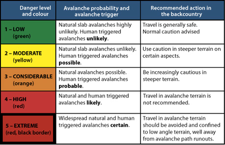
Avalanche warning scale
The has been a worrying number of avalanches with fatalities and we have looked at why in this earlier article on PlanetSKI:
Why are there currently so many fatal avalanches in the Alps?
We reported on the recent incidents this month in these articles with mountain guides and ski instructors getting caught out.
- Two mountain guides die in separate accidents in Switzerland
- 38-year old British man dies in avalanche in Verbier
- Second fatal avalanche in Verbier
- One of the world’s top freeriders searches for friend in Verbier avalanche
In France, where the lifts are closed but people are hiking up, there have also been further fatalities.
A ski tourer has died near the resort of Aussois and another person perished in Alpe d’Huez.
The avalanche risk was 3 on a scale of 5 in both incidents, meaning there was “considerable” danger.
The slide in Alpe d’Huez was described as a ‘large avalanche’ with the person found under 3m of snow.
Both victims had avalanche transceivers and are said to have been experienced.
With snow continuing to fall accompanied by high winds the conditions by Friday will be “critical” in Switzerland.
“On Friday in the northern regions and the Valais, persistent snowfall is expected,” added the Swiss Institute for Snow and Avalanche Studies.
“A strong-to-storm strength wind will be blowing from westerly to northwesterly directions… The avalanche situation in the northern regions, in the Valais and in the northern parts of Grisons will continue to remain at critical levels.”
The authorities continue to urge extreme caution to those people venturing off piste.
The overall forecast for the Alps comes from our resident alpine weather expert, Fraser Wilkin from Weathertoski.co.uk who made these observations on Wednesday 27th January:
“A new storm cycle is affecting the Alps, this time involving warm fronts and very mild subtropical air. This will deliver huge snowfalls at altitude across the northern and western Alps over the next few days, but also a lot of rain lower down.
“By the end of Saturday, between 100cm and 150cm of new snow is expected above 2200m in some favoured spots of the north-western Alps.
“In these ‘warm front’ situations, areas seeing the most snow are usually the high intra-alpine resorts “backed” by high mountains, such as Val Thorens, Tignes, Val d’Isère and Chamonix.
“Swiss resorts such as Verbier, Zermatt, Crans Montana, Mürren and Engelberg will also see a lot of snow, though not quite as much as in their French counterparts.
“The storm will generally have a lesser impact the further east and south you are, though the longer the cold air will hang on.
“Areas that will see the most rain are the northern French Alps (e.g. Portes du Soleil), the northern and western Swiss Alps (e.g. Villars, Gstaad, Jungfrau region), and (later on) the western Austrian Alps (e.g. Arlberg region).
“However, as these areas already have lots of snow (even lower down), the rain should not cause too much of a problem in the long term.
See here for the updates from Weathertoski.