PlanetSKI Snow Report
5th January 2022
Last modified on January 14th, 2022
It’s sunshine all the way across most of the Alps. It’s been cold but now it’s turned milder and there’s no sign of any significant snowfall in the forecast. UPDATED
The big snowfalls earlier this winter meant many resorts in the Alps were able to ride out the mild weather over New Year without serious damage to the snowpack.
But conditions, particularly off-piste and on the lower pistes, took a battering from the unseasonably warm weather and rain.
Even in the high altitude French resort of Tignes, skiers were reporting ‘crazy’ weather over the New Year holiday, with temperatures of 18 degrees Celsius.
The good news is that things are looking up.
There’s been snowfall across most regions, while in the USA it’s been dumping again.
UPDATED:
Friday 14th January
Wow.
What a day for the re-opening of France to UK-based skiers and snowboarders (the vaccinated ones, anyway).
Look at those skies….
https://www.facebook.com/lesarcs/posts/10158289116211759
“High pressure remains in charge of the weather in the Alps, with today being another day of almost wall to wall sunshine,” says Fraser Wilkin of Weathertoski.
“It will feel pleasantly mild in the sun at altitude, especially in the west where freezing levels will again reach or exceed 3000m.”
Fraser says there’s no sign of any heavy or widespread snow any time soon.
https://www.facebook.com/MorzineAvoriaz/posts/6913841828657629
Wednesday 12th January
“Snow conditions are absolutely fabulous with 40-50cm of fresh powder last weekend and blue skies & cold weather this week,” Alix Ostyn in Val Thorens told us this morning.
She sent us this footage put together by the resort videographer on Monday.
https://www.facebook.com/planetski/videos/1948863758630878/
France has had the biggest share of the recent snowfall but conditions elsewhere are reported to be good too.
And it’s due to stay fair across the Alps all week.
Lech in Austria reported temperatures below freezing, clear blue skies and empty slopes on Tuesday.
https://www.facebook.com/lechzuers/posts/10160018808538447
“The sun is shining across virtually the entire Alps today, at least above any of the low cloud which is still plaguing some northern and especially western valleys, where the upper limit is around 1200m,” the alpine snow expert Fraser Wilkin of WeatherToSki says.
“Freezing levels will be close to 2000m in the western Alps, but typically around 500m in the east (ie much of Austria).
“Over the next few days, the weather in the Alps is expected to remain mostly sunny but it will turn milder, with freezing levels reaching 3000m in the west.”
Tuesday 11th January
It’s looking rather good in the French Alps.
Monday 10th January
One of our regular readers reports from Switzerland first thing Monday morning.
That Monday morning feeling – Valais style! #Switzerland pic.twitter.com/PwR0isBwx4
— Valais Dude (@ValaisDude) January 10, 2022
Valais Dude is not the only one set to enjoy a fabulous day on the slopes.
Improving weather conditions in the Alps: https://t.co/PGoKdcOhGN pic.twitter.com/MTgGI3UJtY
— weathertoski (@weathertoski) January 10, 2022
More to follow…
Sunday 9th January
Latest…
Very snowy in the north-western Alps! https://t.co/oGRsHsyUv2 pic.twitter.com/dD0SLlJSlj
— weathertoski (@weathertoski) January 9, 2022
Saturday 8th January
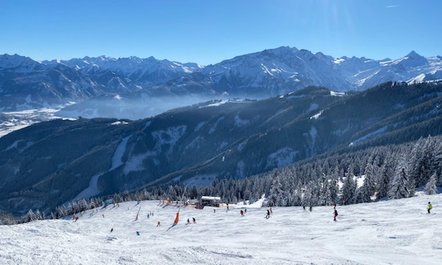
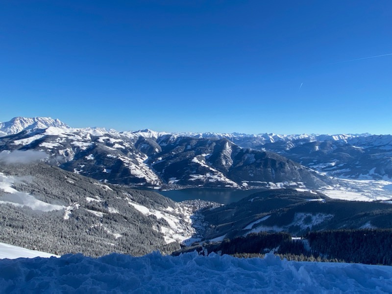
Our reporter Graeme Wallace has been out on the slopes of Zell am See, Kaprun and Saalbach in Austria.
Check out his full report:
Graeme Wallace, Austria. Image c/o Graeme Wallace.
Kaprun, Austria. Image c/o Graeme Wallace.
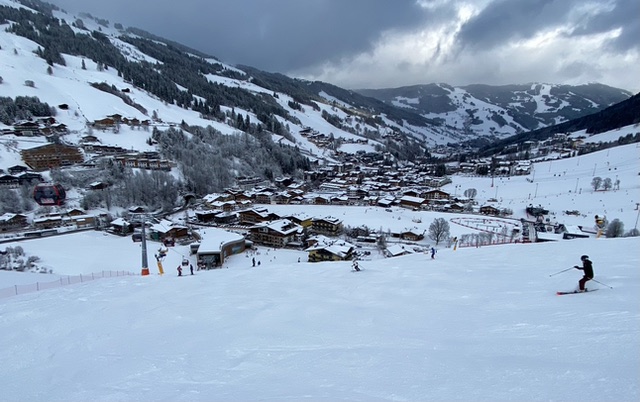
Saalbach, Austria. Image c/o Graeme Wallace.
Zell am See, Austria. Image c/o Graeme Wallace.
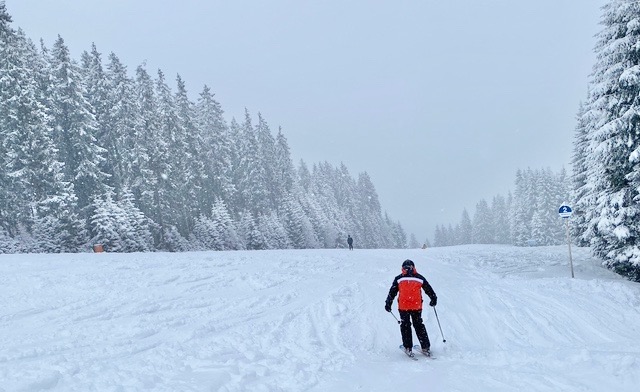
Friday 7th January
After the recent snow across the Alps in the middle of the week the sun is out.
One of our reporters, Graeme Wallace, is in Zell am See in Austria.
Zell am See, Austria. Image c/o Graeme Wallace

Zell am See, Austria. Image c/o Graeme Wallace
Zell am See, Austria. Image c/o Graeme Wallace
“Sunny slopes in Zell this morning,” said Graeme on Friday.
“The snow has transformed the resort with quiet pistes.”
Thursday 6th January
And after the snow, the sunshine.
Today it’s cold and bright across much of the Alps.
https://www.facebook.com/zermatt.matterhorn/posts/10159413249545605
https://www.facebook.com/officedetourismeflaine/posts/6724667540937108
https://www.facebook.com/meribel3vallees/posts/4923411037706659
The next few days look set to be a mix of sunshine and snow showers.
The alpine snow expert, Fraser Wilkin of Weathertoski reported this morning:
“Between now and Sunday evening, between 30-50cm of new snow can be expected across the northern French, western Swiss and far north-western Italian Alps (eg 3 Valleys, Portes du Soleil, Verbier, Jungfrau Region, Courmayeur), with 15-30cm across the eastern Swiss and far western Austrian Alps (eg Klosters, St Anton), but little if any snow in the far eastern and most southern parts of the Alps (eg the Dolomites).”
North America
Across the Atlantic, there’s been more snow to follow the record-breaking falls at the end of December.
Colorado’s resorts have received a big dump and there’s more forecast to come.
Breckenridge reported 15 inches (almost 40cm) overnight.
https://www.facebook.com/CopperMtn/posts/10158444096875812
And this is Steamboat on Wednesday…
https://www.facebook.com/SteamboatResort/videos/453210369602486/
The heavy snowfall has brought with it extremely high risk of avalanche.
The Colorado Avalanche Information Center issued a warning for the Steamboat/Flat Tops and Front Range backcountry zones on Thursday.
“Very dangerous avalanche conditions exist due to heavy snowfall and strong westerly winds,” CAIC said.
“We expect large natural avalanches, and they may run long distances.
“Human triggered avalanches are very likely. Avalanches may break in the storm snow, or break near the ground and entrain the entire snowpack.
“Travel in or below backcountry avalanche terrain is not recommended.”
Wednesday 5th January
https://www.facebook.com/valthorens.resort/videos/933462210644810/
https://www.facebook.com/officedetourismeflaine/posts/6717942758276253
Most regions benefitted from the current storm which continued into Thursday.
This was the scene in Val di Fassa in the Dolomites on Wednesday morning…
https://www.facebook.com/ValdiFassa/videos/279212994194167/
“This morning, the snow is already dying out across the northern French and western Swiss Alps where between 10-20cm has fallen at 2000m with a dusting to as low as 600-800m,” Fraser Wilkin of Weathertoski says.
“By contrast, the snow will linger for most of the day across the central and (especially) the eastern Alps, becoming heavier in the far south-east later.
“So, while storm totals at 2000m in the eastern Swiss Alps (eg Davos, St Moritz) and much of Austria (eg St Anton, Kaprun) are likely to be in the range of 10-25cm, the Dolomites might see 30cm or more by tomorrow morning, with parts of Carinthia (eg Nassfeld) seeing 50-60cm!
“The southern French and south-western Italian Alps will miss most of the action this time around, with just a dusting in Sestriere and nothing at all in Isola 2000.”
The trees have been sprinkled and the temperature is dropping fast – much snow expected in the coming days in 4Vallees #Valais #Switzerland pic.twitter.com/UoXA9IeDED
— Valais Dude (@ValaisDude) January 5, 2022
Meanwhile, if travel restrictions are keeping you away from the Alps, why not consider a trip to Scotland this winter?
It’s been snowing there too, though not yet enough for widespread skiing and snowboarding.
https://www.facebook.com/GlencoeMountain/posts/5336501229710948
We’ll be updating this report so do check back.