More Snow Falling in the Alps
17th December 2023
Last modified on December 24th, 2023
The Alps are going to see some wild weather in places over the next few days. It is generally excellent at altitude in the Alps for the time of year. UPDATED
Saturday 23rd December:
We have been following the weather in France closely over the past few days (see below) with several PlanetSKI reporters in the French Alps.
The weather cleared on Saturday.
“Clear skies are back in La Plagne this morning, with a few extra cms of snow overnight,” said PlanetSKI reporter, Simon Wilson, from the resort.
“The upper pistes are in excellent condition now for the Christmas holidays, but it is a slightly sketchier picture below about 1,800m.”

La Plagne, France. Image c/o PlanetSKI

La Plagne, France. Image c/o PlanetSKI
Now we turn out attention to Austria and Switzerland that are still being hit by a severe weather system coming in from the north.
In Austria the Austrian meteorological service has issued an alert for severe weather for parts of the country.
Friday had cloudy and wet conditions, especially along the Alps, with the snow line varying between 600m and 1,000m.
Heavier snow fell at higher altitudes.
Westerly winds intensified with gale-force gusts, particularly in exposed north and east areas, along with windy conditions in many valleys.
Ski areas have been affected:
It is a similar situation in Switzerland.
Severe weather is forecast to occur across much of Switzerland today.
Heavy snowfall is expected in the Alps with fresh accumulations of 60-120 cm.
At lower altitudes, heavy rainfall is forecast on the central and eastern northern slopes of the Alps, with rainfall totals of 6-9 cm.
Strong winds are also expected across much of the country with gusts of 110-170 kph (68-106 mph) possible in the higher Alpine areas.
Hazardous travel conditions are likely in mountain regions with reduced visibility caused by wind-blown snow.
MeteoSwiss has issued the following weather warnings across the country:
- Red heavy snowfall warnings (the highest level on a three-tier scale): Parts of east-central and eastern Switzerland.
- Orange heavy rainfall warnings: Across parts of central and eastern Switzerland.
- Orange heavy snowfall warnings: Across parts of central, eastern, and southern Switzerland.
- Orange strong wind warnings: Across much of central and eastern and parts of southern Switzerland.
- Yellow heavy rainfall warnings: Across parts of western Switzerland.
- Yellow heavy snowfall warnings: Across parts of southeastern and southern Switzerland.
- Yellow strong wind warnings: Across much of the rest of Switzerland not under orange strong wind warnings.
There is ‘considerable’ risk of avalanche in much of the Swiss Alps with a ‘high’ risk in the east.

Image c/o Swiss Avalanche Institute
More to follow…
Friday 22nd December
As the latest storm hits the northern Alps all eyes are on the temperature.
Where will the freezing level be today?
Will it be rain or will it be snow?
“In La Plagne first thing this morning it was at about 2,000m and around 10cm or so of fresh snow in had fallen,” said PlanetSKI reporter Simon Wilson from the resort.

La Plagne, France. Image c/o PlanetSKI
“Temperatures have dropped a little but only just below freezing and am a bit concerned again about where he rain snow limit will sit today.
“Out on the slopes there was what is best described as ‘freezing drizzle’ on the mountain in Belle Plagne a freezing directly onto goggles. Marvellous!”

La Plagne, France. Image c/o PlanetSKI

La Plagne, France. Image c/o PlanetSKI
More to follow…
Thursday 21st December
Another big storm has started in the northern Alps with resorts in France, Switzerland and Austria seeing snow at altitude, but rain lower down.
Some forecasts say around 1m of snow may fall in places once the latest storm has passed.
Here’s the current scene in La Plagne on Thursday evening.

La Plagne, France. Image c/o PlanetSKI.
The freezing level today has been between 1,000m and 1,400m.
“Tonight, the precipitation will intensify across the northern Alps, lasting all day tomorrow and into Saturday, heaviest in the central/eastern Swiss and Austria Alps,” said the alpine weather expert, Fraser Wilkin, from weathertoski.co.uk.
“The rain/snow limit will change a little, generally sitting between 1000m and 1500m, perhaps a touch lower in places at times.”
The storm will also have strong winds and this will mean many lifts at altitude will be closed.
It will also increase the avalanche risk.
“The rain/snow limit was all over the place today here – up to 2,000m at times,” said PlanetSKI reporter, Simon Wilson, from the Paradiski area in France.
“We are hoping it snows properly as promised overnight.
“Just a few centimeters of very wet snow at resort level here 1,800m.”
Simon is in the Paradiski area reporting on its 20th birthday celebrations:

Paradiski, France. Image c/o Olivier Allamand
We will be hearing from our reporters currently out in the Alps later, so do check back for the very latest.

Paradiski, France. Image c/o PlanetSKI
Meanwhile, what about conditions in North America?
Generally it has not been a bumper start to the season in both the USA and Canada, but it is early days.
PlanetSKI’s Ross Young is in Banff in Alberta, Canada with his son, Fynn.
“Today I visited Norquay, Banff’s local ski hill and the smallest of the SkiBig3 resorts with just the six lifts,” said Ross.
“The good news is that they’re all running and 45 of Norquay’s 60 pistes are open.
“Conditions at Norquay definitely have an early-season feel – another few inches of base would really make a difference.
“Even so, at the start of the day the groomed runs were in excellent shape – perfect for a cobweb-removing blast.
“By the early afternoon it was a different story.
“With the temperature only a couple of degrees below zero, the snow began to slush up a little.
“Norquay’s off-piste is skiable in parts, but coverage is still patchy, with the occasional rock visible. I was thankful I’m on rental skis.”

Mt Norquay, Banff. Image c/o Ross Young.
Fynn spent the day in Lake Louise, where he had better luck with the weather.
“An inch or two of snow fell during the day, refreshing the lower slopes and making the copious off-piste more forgiving,” said Fynn.

Lake Louise, Canada. Image c/o Ross Young.

Lake Louise, Canada. Image c/o Ross Young.
More to follow…
Wednesday 20th December
The weather is changing today with the blue skies being replaced by cloud and some flurries of snow in places.
On Thursday the next storm gets going with the northern Swiss and Austrian Alps being hit.
The all-important freezing level is forecast to be between 1,000m and 1,500m.
There will be high winds at altitude.
“Between now and the end of Saturday, we are expecting some very significant snowfall totals above 1500m across some regions, especially the central/north-eastern Swiss and northern Austrian Alps (e.g. Arlberg/Vorarlberg) where over 1m is possible,” said Fraser Wilkin from weathertoski.co.uk.
“By Sunday, it will have turned milder with the rain/snow limit rising to above 2000m in places, although the precipitation will be lighter.”
See here for the latest on weathertoski.co.uk
PlanetSKI’s Simon Wilson is currently in La Plagne & Les Arcs in the Paradiski area in France.
“Piste skiing across the Paradiski area has been very good – pretty exceptional for December,” said Simon.
“Definitely helped by the fact French school holidays don’t start until the weekend, so the slopes were unusually quiet in both Les Arcs and La Plagne.
“Only slight disappointment in both resorts was that the highest lifts remained closed today – no Aiguille Rouge in Les Arcs and the new Glaciers bubble in La Plagne is not scheduled to open until the coming weekend.
“But pistes overall are so good and empty with no lift queues that it really didn’t matter.
“It’s all change in the forecast from today – cloudy and colder weather on the way for the rest of the week, though forecasts vary widely on how much snow might actually fall in the French Alps.”

Arc 1950, France. Image c/o PlanetSKI

Paradiski, France. Image c/o PlanetSKI

Paradiski, France. Image c/o PlanetSKI
More to follow…
Tuesday 19th December
The freezing level has risen to around 3,000m in parts of the western and northern Alps with blue sky overhead.
However, as the sun is low in the sky its rays as are not as strong as they will be later in the season so the snowpack has suffered less.
The current weather will continue until mid-week as high pressure dominates, but this will change on Wednesday.
Overall as we approach Xmas the conditions are some of the best in recent memory.
At altitude they are generally excellent, but the heavy rain of last week decimated the snow pack at some low-level resorts in parts of the Alps.
Further east and further south there has been less snow and therefore less rain so despite more modest depths the conditions remain good, topped up by snow guns.
We mentioned earlier that we were posting a few updates from our readers & reporters who have been out on the slopes of the French Alps these part few days:
Les Menuires – Vanessa Fisher
“Two days of epic blue skies and all pistes in amazing condition around Les Menuires itself.
“We have skied all the way to Orelle in one direction and La Tania in the other as well as down to St Martin de Belleville a few times, so great mileage each day.
“It has been mild in the sunshine but the low sunshine at this time of year is not really affecting the snow.
“Still lots of pockets of lovely shallow powder off piste.
“Sunday 17th was busier with more French locals in the area but apart from a couple of cross over points, the slopes have been lovely and quiet.”

Les Menuires, France. Image c/o Vanessa Fisher.

Les Menuires, France. Image c/o Vanessa Fisher.
“We had a brilliant catch up and blast about with Chris Moran, our friend from PlanetSKI partner, Intersport.
“He met us in La Tania and joined us all the way back over and down to St Martin de Belleville – Fast piste cruising at its best.”

Les Menuires, France. Image c/o Vanessa Fisher.
Tignes – Tord Nilson
“Incredible snow conditions with an amazing base now ready for the whole season – skiing thigh deep powder is pretty incredible in December!
“Everyone very excited in town with conditions looking like they will be perfect for the festive period.
“If you’re skiing off piste, please be careful and avi gear is ESSENTIAL, we saw plenty of snow slipping in the last couple of days so stay safe out there.
“The piste are amazing so don’t take the risk!”

Tignes, France. Image c/o Tord Nilson

Tignes, France. Image c/o Tord Nilson
Flaine – Paul Hansgate
“The first thing to say is that the snow is absolutely awesome.
“I have rarely skied in a non-glacial resort this early in the season which had such large quantities of fresh, powdery snow and under such incredible blue skies without a cloud in sight.
“Sure, the temperatures have crept up to 6 or 7 degrees in the midday sun but the rays are not so strong at the this time of year and the snow is holding up remarkably well.
“With 300cm already at the top of the slopes at Grand Platieres and 60cm of snow at the base this could be an epic winter.
Paul runs the company, Hanski, and its star “ski in and ski out” accommodation Les Terrasses d’Eos is always a firm favourite with his clients for the spacious, comfortable, well-equipped apartments and the ease of access to the slopes.
See here for more details: Hanski

Flaine, France. Image c/o Paul Hansgate

Flaine, France. Image c/o Paul Hansgate
Vaujany/Alpe d’Huez – Tim Clark
“The resort has a decent snow pack of 59cm, but clear skies and temperatures which are close to t-shirt weather.
“The warm blip arrived on Friday and is set to last until Wednesday when the cold returns.
“For the next few days however it means the resort, and the neighbouring Vaujany where I’m staying is enjoying very good ski conditions and little in the way of crowds.
“The snowpack in Vaujany is solid down to around 1600metres with no slush to be seen.
“Alpe d’Huez had snow down to town level, however Vaujany at 1,250 is mostly snow free.
“The snowfall, which fell as recently as on Wednesday, has helped ease the pistes into a good consistency and there is ample off piste for those who want it.
“There are icy patches from around 2,800 and above, especially on north facing slopes down from the Dome Des Rousses such as the red Led Rousses, and Chamois but the afternoon sun softened these as the day wore on.
“The only other striking feature of the day is the lack of people, at least for now.
“For the first two hours it felt like we had the slopes to ourselves.
“Alpe de Huez will inevitably get busier as Christmas approaches but for the coming week it’s a veritable ski paradise.”

Vaujany/Alpe d’Huez, France. Image c/o Tim Clark.

Vaujany/Alpe d’Huez, France. Image c/o Tim Clark.
More to follow…
Monday 18th December
We have been hearing extensively on conditions in the Alps and North America in recent weeks from our reporters out in the mountains.
We will have a full update on Tuesday about conditions in the Alps and what the Xmas period may look like.
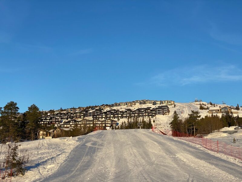
But today we hear from Norway – PlanetSKI editor, James Cove, is currently in Norefjell.
And here are those lower pistes James was talking about.
Perfect for high-speed carving, with barely a soul around:
And just as good lower down:

Norefjell, Norway. Image © PlanetSKI
The day for James began with a fabulous dawn as he flung open the curtains of his hotel room at the Norfejell Ski & Spa as the sun rose.
Not a bad start to a Monday morning.

Norefjell, Norway. Image © PlanetSKI

Norefjell, Norway. Image © PlanetSKI

Norefjell, Norway. Image © PlanetSKI
An hour later, after breakfast, it was a bit lighter.
James flew in to Norway on Sunday.
He was on the inaugural Crystal Ski charter flight from Gatwick to Oslo:

Crystal charter to Oslo. Image © PlanetSKI
So, in general what is skiing like in Norway at this time of year?
“In a word, fabulous,” said James.
That’s why he’s often be found in Norway in December.
He had the pistes pretty much to himself with just a handful of people around.
Norefjell, Norway. Image © PlanetSKI
Norefjell, Norway. Image © PlanetSKI

Norefjell, Norway. Image © PlanetSKI
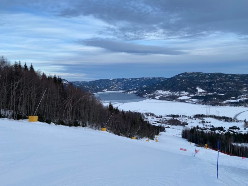
Winter has only just got going, so the lakes in this part of Norway are not totally frozen over.

Norefjell, Norway. Image © PlanetSKI
There there are the hours of daylight as it is far north.
The sun does get above the horizon in mid -December, but not by much.
This image was taken at 11am.

Norefjell, Norway. Image © PlanetSKI
This one at 2pm.

Norefjell, Norway. Image © PlanetSKI
Shortly after 2.30pm James called it a day, though lifts officially continue to around 3pm.

Norefjell, Norway. Image © PlanetSKI
Tomorrow, Tuesday 19th December, PlanetSKI will be turning its attention back to the Alps and focusing on France as we hear from several of our reporters out on the slopes of Flaine, Tignes, Les Menuires and Alpe d’Huez.
James is particularly interested in those reports, as he is leaving Norway later this week and heading over to Les Arcs in France for the Xmas break.
More to follow…
Sunday 17th December
Blue sky has arrived in the northern and western Alps with high pressure dominating proceedings.
The temperature has shot up with warm conditions prevailing.
It has been mostly sunny, and the freezing level has been well over 2,500m in places.
Temperatures are set to remain well above average for the time of year.
The massive fluctuations in temperatures have been a real aspect to the start of this winter so far, and have been one of the key indicators of conditions.
It is set to stay clear for the first part of the week with some cloud returning to the western Alps mid-week.
It has been a bit of a roller-coaster this past week or so and we have been following all the twists and turns in the weather as the ski season of 2023/24 gets underway:
PlanetSKI reporter, Simon Wilson, is in La Plagne France.
Here were his observations first thing on Sunday morning:
“Sunny and mild weather forecast for next two to three days at least,” said Simon.
“It is freezing at resort level but I am told it is -2c down in the valley with an inversion in place.
“There remains ‘considerable’ avalanche risk at altitude with the danger standing at Level 3 on a scale 5.
“Looks like most of the resort will be open today.”

La Plagne, France. Image c/o PlanetSKI

La Plagne, France. Image c/o PlanetSKI

La Plagne, France. Image c/o PlanetSKI

La Plagne, France. Image c/o PlanetSKI
And here is Simon’s update after a day on the slopes:
“The pistes in La Plagne are in excellent condition generally- the higher the better of course,” said Simon.
“It has been so warm today that south facing slopes were already getting soft by late morning and it was more like good spring piste skiing.
“The bowl above Plagne Centre is skiing particularly well with some pockets of powder still not completely skied out.
“Lower down towards Les Coches and Montchavin you can tell the pistes took a battering from the rain – but they have been topped up with arrival snow and perfectly skiable.”

La Plagne, France. Image c/o PlanetSKI

La Plagne, France. Image c/o PlanetSKI
PlanetSKI editor, James Cove, has arrived in Norway today – he is yet to put skis on with conditions looking good, though not spectacular.
“There was some excellent snow here a few days ago with locals talking about it as an excellent start,” said James.
‘Though the temperatures have been high in recent days with some strong winds that have made the slopes hard-packed and icy.”

Heading for skiing in Norway. Image © PlanetSKI

Norefjell, Norway. Image © PlanetSKI
James has flown into Norway on the inaugural Crystal Ski charter flight into Oslo that is set to bring thousands of UK skiers and snowboarders to Norway this winter:
Crystal charter to Oslo. Image © PlanetSKI
Over in Canada PlanetSKI reporter, Ross Young, has been skiing this weekend in Lake Louise, near Banff.
“Thanks to a couple of snowfalls over the last few days the groomed runs are in great nick, especially the tree-lined slopes in the Larch area,” said Ross.
“The off-piste is skiable and great fun but it’s early season, so there’s still the occasional exposed rock to watch out for.
“Lower down the mountain, the skiing was good in the morning, but towards the end of the day the runs became icy in places.
“With no big dumps predicted over the next few days, we’ll be keeping our fingers crossed that the occasional flurry will top snow levels up.
“If that doesn’t happen, at least we’ll have the scenery to console us – Lake Louise is gorgeous.”

Lake Louise, Canada. Image © Ross Young

Lake Louise, Canada. Image © Ross Young
More to follow…
![]()
![]()