The PlanetSKI Snow Report
1st January 2024
Last modified on January 6th, 2024
Saturday 6th January.
The forecast snow has duly fallen in the Alps and the Pyrenees as winter re-starts.
PlanetSKI editor, James Cove, has just arrived in the French Pyrenees.
More about the Pyrenees later, first we look at the Alps.
Here’s Val Thorens in the the western French Alps.
It is the highest resort in the Alps at 2,300m.
It has finally been snowing down to lower levels too as the temperature drops.
Morzine, 1000m, has at last seen a decent amount of fresh snow.
“A great day on the slopes, thanks to the snowflakes,” said the resort on Friday.
“And the fun should continue with this weekend’s snow.”
And here’s Klosters in eastern Switzerland.
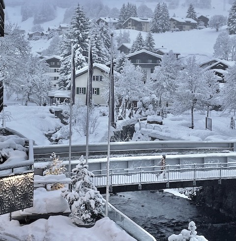
Klosters, Switzerland. Image c/o Heather Jefferies.
There have been good snow falls in many areas in between and beyond into Austria and Italy.
“Most other parts of the Alps have also seen or are seeing some fresh snow from this latest storm, with the rain/snow limit continuing to fall today to around 500m in the northern Alps, and 800m later in the southern Alps,” said the alpine weather expert, Fraser Wilkin, from weathertoski.co.uk on Saturday morning
“It will remain wintry tonight and tomorrow with snow showers to very low levels almost anywhere, but increasingly favouring the northern foothills of the Alps.
“The wind will also increase, becoming very strong at altitude on Sunday.”
As we have mentioned PlanetSKI has just arrive in Ax-3-Domaines in the French Pyrenees and we’ll be updating from the resort later today ahead of moving onto Andorra next week as we spend much of January in the Pyrenees.\
Do check back for that.
Here’s the scene in Andorra from our friends at Andorra Travel Service:
More to follow…
Friday 5th January
The temperatures are falling across Europe with heavy snow forecast this weekend in parts of the Alps and the Pyrenees.
The arctic weather has already hit Scandinavia as we have reported on PlanetSKI.
Here’s a look at the temperature map in France with cold temperatures in the Alps and the Pyrenees:
🌡️ Changement radical de temps entre ce jeudi et mardi prochain ! La #douceur actuelle ne sera plus qu’un souvenir. Mardi prochain, il fera très froid avec une journée sans #dégel sur les 3/4 du pays ! pic.twitter.com/2KYMXCz6X9
— La Chaîne Météo (@lachainemeteo) January 4, 2024
Here at PlanetSKI we have arrived in the French Pyrenees – Ax-3-Domaines to be precise.
It was raining at resort level with the promise of powder snow up on the slopes on Saturday.
It is the first major storm of a below par winter so far in the Pyrenees.
It seems that PlanetSKI is once again in the right place at the right time.
Do look out for our reports at the weekend and over the coming few weeks as we move on to Andorra and then Spain.
Here’s what it looks like in Andorra today:
It seems the weekend’s weather could be quite wild according to Meteo Pyrenees.
“Strong gale from the north at altitude which will begin Saturday evening until Monday with gusts beyond 100/120 km/h at the bottom of the range and on the east of the range or even more in exposed areas. Pass closures are likely + snowdrifts,” said Meteo Pyrenees in a forecast.
Over in the Alps the forecast is looking good, and finally the lower resorts should experience cold winter temperatures and some snow.
All parts of the Alps are in with a good chance of significant snow by the end of the weekend, by which time it will also have turned much colder.

Les Carroz, France. Crédit photo : Office de Tourisme.
It seems widespread winter conditions are finally here.
Over in North America it is, sadly, a different story with winter proper yet to get underway:
More to follow…
Thursday 4th January
There’s some rather good news – decent amounts of snow are forecast to fall in both the Alps and the Pyrenees as the weekend approaches.
At PlanetSKI we are particularly excited about the Pyrenees as we are currently on our way there.
We’ll be in the mountain range by the end of this week and for most of January – hitting resorts in France, Andorra and then Spain.
It’s looking good:
Un épisode hivernal est confirmé à partir de vendredi. Il devrait tomber au moins 30 à 50cm de #neige sur l’ensemble du massif (dès la moyenne montagne). Le vent de nord s’annonce fort et les flocons devraient s’inviter jusqu’au piémont dimanche. 📷Meteociel pic.twitter.com/vMvW3dixe8
— Météo Pyrénées (@Meteo_Pyrenees) January 2, 2024
More about the Pyrenees later, but first the weather in the Alps
There was some fine weather on Wednesday, and some snow started to fall in the northern Alps as the day progressed.
It is hopefully a foretaste of what is to come at the weekend.

Les Arcs, France. Image © PlanetSKI
“After something of a reprieve on Thursday, another storm will move in from the south-west late on Friday,” said the alpine weather expert, Fraser Wilkin from weathertoski.co.uk, on Wednesday.
“This will merge with other weather fronts coming down from the north-west on Saturday and Sunday, meaning that all parts of the Alps are in with a good chance of significant snow by the end of the weekend, by which time it will also have turned much colder.”
Quite a lot going on in the Rhône valley weather wise today! High winds and temperature inversion pic.twitter.com/h4Ja1hXsnQ
— Valais Dude (@ValaisDude) January 3, 2024
In the Pyrenees decent amounts of snow are also set to fall.
It will be more than welcome after a poor start to winter that has seen little natural snowfall, though the pistes have been topped up by the snow cannons.
It seems snow chains may be needed this weekend as we arrive with up to 50cm in the forecast:
“Special monitoring from tomorrow morning until Monday for this winter episode traffic difficulties are to be expected on Saturday and Sunday for vacation returns on the roads from the resorts and Andorra,” said Meteo Pyrenees on Thursday.
More about PlanetSKI’s trip to the Pyrenees in Tuesday’s report.
Tuesday 2nd January
First we look at the Pyrenees where there has been a dusting of snow.
Here was Andorra at the weekend:
There is much more snow in the forecast with heavy snow predicted for Friday.
It will be very welcome if it arrives as winter has got off to a slow start.
As luck (and planning) would have it PlanetSKI editor, James Cove, will be in the Pyrenees later in the week.
He’s heading to the French Pyrenees first, and then to Grandvalira in Andorra.
Later in the January he’ll be in the Spanish Pyrenees.
“Conditions so far this winter have not been great in the Pyrenees with some wildly fluctuating temperatures,” said James.
“However I’ll be in the mountain range for most of January, so fingers crossed things will improve.
“There is some fabulous skiing in the Pyrenees and may many people mistakenly overlook it.”
Spain’s Baqueira Beret currently has base depths of 40/50cm while France’s La Mongie has 30/40cm.
In Andorra some of the best skiing is to be found at Pas de la Casa.
Bon réveillon au Pas de la Casa ❄️ avec quelques flocons ou ailleurs pic.twitter.com/Pqo85wdpEI
— Météo Pyrénées (@Meteo_Pyrenees) December 31, 2023
Look out for the reports from James as we concentrate on Europe’s other mountain range over the coming weeks.
More to follow…
Monday 1st January
As forecast, the latest storm has brought a small amount of overnight snow to parts of the northern and western Alps.
Monday is a generally calm day, but the snow will return on Tuesday.
“Snowing in the mountains down to 1200 m or so at first, then down to 1600/1800 m as the day warms up (so rain at lower altitudes), but then down to 1400 m or so overnight,” said Henry Schniewind from Val d’Isere in France.
“Between 15 to 25 cm of fresh snow expected above 1900 m, and up to 30 cm above 2200 m by Wednesday morning.”
See here about the off piste conditions in the area: Henry’s Avalanche Talk.
Over New Year it was falling down to 1,000m in places and has been a welcome sight in some of the lower resorts that have been struggling.
Here is Les Gets on New Year’s Eve:
Snowing across a good part of the Alps today/tonight. This is #LesGets pic.twitter.com/2Zc7ufZUhH
— weathertoski (@weathertoski) December 31, 2023
It’s been falling elsewhere but the early January temperatures are set to be mild.
❄️❄️❄️ Snowing in #LaTania ❄️❄️❄️ pic.twitter.com/wwWaKVpX2M
— La Tania (@La_Tania) December 31, 2023
❄️ Il neige à gros flocons dans les Alpes en ces dernières heures de l’année 2023. Images depuis Valloire en Savoie. (© Le P’tit Galibier) pic.twitter.com/LtuKslsNwH
— Météo Express (@MeteoExpress) December 31, 2023
As we enter 2024 much of the Alps at altitude has good snow, though warm temperatures have caused problems lower down.
There has been less snow in the southern Alps, including Italy, but the snow guns have been doing their work and most runs are open.
See here for last week’s rolling snow report:
PlanetSKI has been in Les Arcs, France over the festive season:
Prior to that we were in Norway, where winter has got off to a good start:
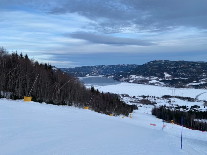
Norefjell, Norway. Image © PlanetSKI
And lets not forget Scotland.
Here’s Glencoe:
More to follow…
![]()
![]()