Blue Sky & Powder Across Large Parts of the Alps
15th January 2023
Last modified on January 24th, 2023
Updated:
And it’s looking pretty good in La Clusaz.
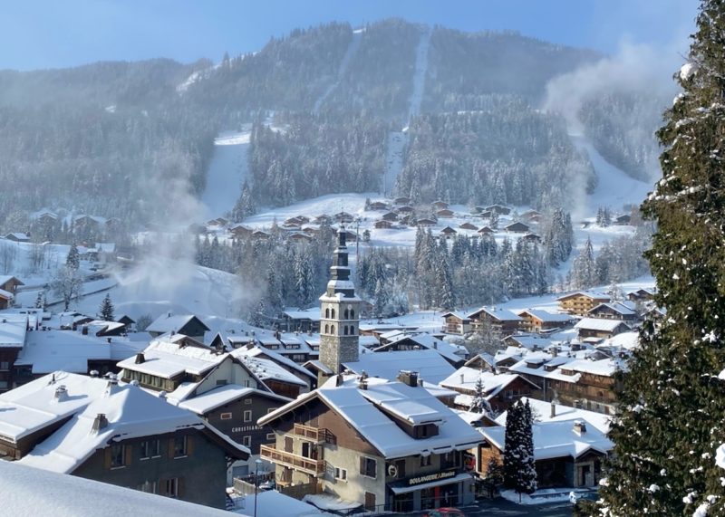
La Clusaz, France. Image © PlanetSKI

La Clusaz, France. Image © PlanetSKI
La Clusaz, France. Image © PlanetSKI
More to follow…
Sunday 22nd January
So, what’s the snow like today and what’s in the forecast for the week ahead?
The PlanetSKI editor, James Cove, has the answers in this video snow report direct from the Alps.
The avalanche risk is decreasing in some parts of the Alps after all the fresh snow.
In Switzerland the snow pack is becoming more stable and a smaller area of the Swiss Alps in under a Level 3 alert.
Level 3 is where 65% of fatalities occur as people think it is safe when it is not.
Level 3 means there is “considerable” danger.

Avalanche risk in Switzerland, Sunday 22nd January
“At elevated altitudes a considerable avalanche danger will be encountered in some regions,” said the Swiss Institute for Avalanche Research.
In Switzerland 4 people have died in avalanches with the last one being in Davos on Sunday 15th January.
Across the Alps caution is urged off piste.
Saturday 21st January:
It looks like it is going to be a pretty good weekend for those out in the resorts that have seen the fresh snow.
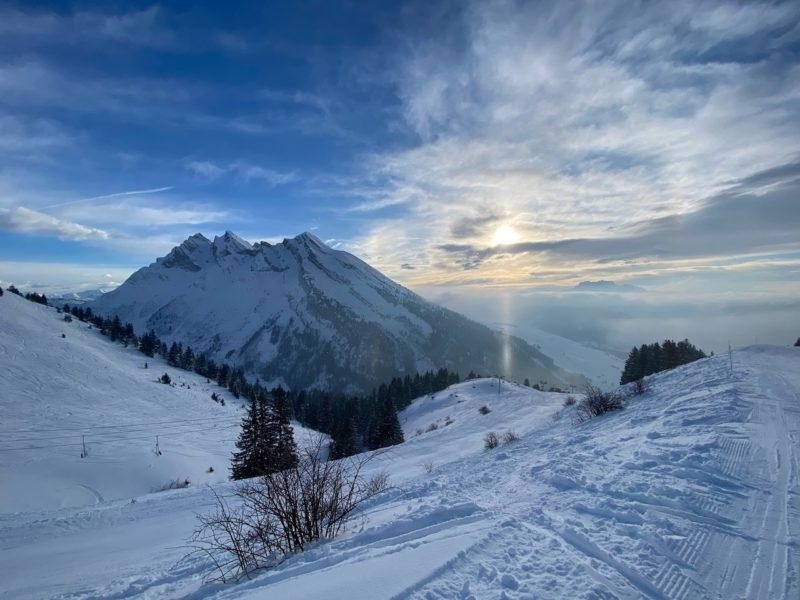
This is the view (front and back) from where the PlanetSKI editor, James Cove, is staying in the Swiss resort of Verbier in the north-west Alps.

Verbier, Switzerland. Image c/o PlanetSKI
It is clear and cold across the western Alps – home to many of the major resorts in France and Switzerland.
It has been very cold and is -15c in the resort of Verbier.
Up at the top first thing this morning it was -20c.

Verbier, Switzerland. Image c/o PlanetSKI
“The cold temperatures are preserving the snow really well and giving us light and dry powder,”said the PlanetSKI editor, James Cove.
“Some of the turns I have been making off piste remind my of those glory days in North America.
“I skied down Tortin the other day and there was 70cm of deep powder.
“So often it snows in the Alps and then the temperature shoots up and the snow becomes thick and heavy. Not now.”

James in the Verbier powder. Image c/o Helly Hansen and Craig Paterson.
We are currently getting the latest information across the Alps from Fraser Wilkin at weathertoski.co.uk
“There is further snow down to low levels in the north-eastern Alps and mostly sunny skies further west and south.
“The areas of Austria seeing snow falling are the ones that saw the least snow earlier this week, which will partially address the balance across the northern Alps.
“Overall though, it is the French Alps that are now in the best shape, with deep blue skies and powdery snow at all levels.”
We’ll be updating later on conditions across the Alps so do check back.
Thursday 19th January
The game changing snow storm that was forecast has delivered.
“Not very long ago there was almost no snow in the lower resorts of the north-western Alps, but this week these areas (e.g. Samoens, Les Carroz, Megeve, La Clusaz, Les Gets, Morzine, Villars, Gstaad) have seen a dramatic turn-around,” said Fraser Wilkin from weathertoski.co.uk
“Conditions here are now excellent or, at least, will be once the weather settles down.
“It’s worth noting though that at altitude the risk of avalanche is high, partly due to all the new snow but also due to the wind, which was particularly strong yesterday.”
The weather in the north-western Alps cleared for the early part of the day before another storm came in mid-afternoon.
PlanetSKI is in Verbier and our editor James Cove hit the powder as the sun finally made an appearance.
Check out his full report here:
James in the Verbier powder. Image c/o Helly Hansen and Craig Paterson.
Wednesday 18th January
It looked pretty good overnight in Verbier as more snow fell.

Verbier, Switzerland. Image c/o PlanetSKI
And rather tasty first thing in the morning as another powder day beckoned.


Verbier, Switzerland. Image c/o PlanetSKI
Our chief reporter Jane Peel is in Morzine in France and has compiled a photo gallery with some stunning images taken this morning when the snow stopped – briefly.

Morzine. Image © PlanetSKI

Morzine. Image © PlanetSKI

Morzine. Image © PlanetSKI
Tuesday 17th January
The storm is continuing across the Alps with snow coming down in the Pyrenees too.
One of the key factors influencing the current snow is the temperature.
It has dropped sharply due to a cold from coming from the north.
On Monday the freezing level in the north-western Alps dropped from around 1,800 to 600m across the day.
This meant the lower slopes received a good fall of snow.
Without the drop it would have been rain, as happened a few weeks ago.
Among them is Morzine in the Portes du Soleil, which has seen some of significant snow in the last 48 hours.
The latest PlanetSKI snow report comes from our chief reporter Jane Peel who’s there.
https://www.facebook.com/planetski/videos/1142120699826722/
You can read Jane’s report from Morzine here:
PlanetSKI is also in Verbier.
The village down the valley from Verbier at 1,500m is Le Chable at 821m.
One of our regular readers and a good friend of PlanetSKI is Steve Sparks, who lives in the village – he has sent us these pictures to illustrate the point.

Le Chable, Switzerland. Image c/o Steve Sparks

Le Chable, Switzerland. Image c/o Steve Sparks
Le Chable, Switzerland. Image c/o Steve Sparks
We’ll be looking in detail at the snow depths and how much snow is falling later, but first a word of caution if you are thinking of heading off piste.
The avalanche danger is at Level 3 on a scale of 5 in many areas were the snow is falling.
It means there is “considerable” risk.
“Considerable avalanche danger will be encountered over a wide area,” said the Swiss Institute for Avalanche Research.
65% of avalanche fatalities occur at Level 3.

PlanetSKI’s editor, James Cove, is currently in Verbier in Switzerland.
He is with Warren Smith, from the Warren Smith Ski Academy, and the Helly Hansen crew.
Warren has some words of advice given the current situation.
We’ll be hitting the powder with Warren later today – early signs are rather impressive.
This was the view from James’s hotel balcony as he flung open the curtains on Tuesday morning:

Verbier, France. Image © PlanetSKI
Looking good.
Do check back…
Monday 16th January
The predicted snowstorm is well underway.
Some of the resorts that suffered the most in the recent snow drought are now getting the best of it.
Heavy snow is falling in Morzine and Les Gets in the Portes du Soleil in France.
PlanetSKI’s chief reporter, Jane Peel, is in Morzine.
“They may not have had much – or, in fact, any – snow in Morzine town little more than a week ago, but the latest snowstorm has certainly delivered, giving a boost to ski tourism in the French resort,” said Jane.
This is how the town centre looked around 4pm on Monday.

Morzine, France. Image © PlanetSKI
Jane has posted a separate article about her day and she’ll be looking at the impact on the resort of all the negative publicity it received earlier as the snow refused to fall.

Jane in the trees down to Les Lindarets, Portes du Soleil, France. Image © PlanetSKI
Flaine too is seeing some heavy snow.
“It’s chucking it down!” said regular reader, Lynsey Devon.
The snow has also started to fall in Verbier where our editor, James Cove, is.
“The snow began falling late morning and is getting heavier and heavier. There is thick cloud at altitude so I’m sticking to the lower runs,” said James in the morning.

James is out with the instructor Warren Smith and the Helly Hansen crew and in the afternoon they headed to the powder.
There is also heavy snow falling over in the south-east Alps with parts of Austria and the Dolomites benefiting.
And the forecast…
Latest snow forecast this Monday Morning (running from 16 Jan to 1 Feb 2023) … looking good across all our favourite ski areas in Europe🤩 @wxcharts pic.twitter.com/gUQl91qdkJ
— PlanetSKI Snow News (@planetski) January 16, 2023
As we have been saying on PlanetSKI, the key thing at the moment is the temperature – the freezing level is down to 600m in the north-western Alps.
Happy Days!
Sunday 15th January
A series of storms are due to hit large parts of the Alps with up to 1m of snow forecast in places, though of course we will have to wait and see the exact details.
Some forecast models are changing and say it may be less than was earlier thought.
The area set to see the most snow is the north-western Alps where the PlanetSKI editor, James Cove, currently is:
James mentioned that he has been staying down the valley in Le Chable last week, see here for his reports:
It looked good as the current snow started on Sunday.
This was mid-morning in Verbier as the snow began to fall:

Verbier, Switzerland. Image © PlanetSKI
And by the end of the afternoon:

Verbier, Switzerland. Image © PlanetSKI
The key statistic for the low-level resorts, that have had a torrid time of it in recent weeks, is the temperature.
Snow will be falling, not rain, as an arctic airmass moves down from the north.
PlanetSKI’s chief reporter Jane Peel arrived in Morzine in France (1,000m) on Sunday evening.
En route she passed through Les Gets.
It had no snow at resort level a week ago.
Conditions were so un-wintry that they opened up the mountain bike tracks on Mont Chery.
“It’s great to see it the town all white, just as it should be in January,” Jane said.

Les Gets, France, Sunday 14th January. Image © PlanetSKI
“They’ve still got some work to do on the lower pistes but the link between Morzine and Les Gets is due to open on Tuesday morning and I’m looking forward to skiing it.”
It is going to remain cold all week.
“After a tricky start to the season in places, the storms we are expecting will be a game-changer and an enormous relief to lower-lying resorts impacted by the recent mild weather,” said the managing director of Ski Solutions, Craig Burton.
“We have a stormy, snowy week coming up, but when the skies clear the conditions will be incredible and set most resorts up perfectly for the season ahead.”
“Booking demand in recent weeks has been concentrated towards higher altitude destinations in the Alps and Norway, but with all resorts set to benefit from this snow, we are preparing ourselves for an avalanche of bookings in the next few days,” added Craig.
The other area of the Alps set to see good levels of snow is southern Austria and perhaps the Dolomites in Italy.
In western Austria there has been some good recent conditions in St Anton in the Tirol with snow down to resort level.

St Anton, Austria. © TVB St. Anton am Arlberg_Jakub Sedivy

St Anton, Austria. © TVB St. Anton am Arlberg_Jakub Sedivy

St Anton, Austria. © TVB St. Anton am Arlberg_Jakub Sedivy
And as the afternoon ended in Verbier:

Verbier, Switzerland. Image © PlanetSKI

Verbier, Switzerland. Image © PlanetSKI
The Pyrenees
And lets not forget the Pyrenees where snow is coming down too:
Y lo mejor de todo es que solo acaba de empezar 😜 pic.twitter.com/46FJqtELJJ
— FORMIGAL (Aramon) (@AramonFormigal) January 16, 2023
+25cm à La Mongie 1800m pic.twitter.com/IsaMocxUzs
— Météo Pyrénées (@Meteo_Pyrenees) January 16, 2023
Do check back for our updates across the week…
PlanetSKI logo