The PlanetSKI Snow Report
30th January 2022
Last modified on February 7th, 2022
There has been some fresh snow in parts of the Alps, but also some high winds in places. PlanetSKI’s main team is in the windy part, rather than the snowy part. Check out the latest… UPDATED
Updated: Monday 7th February
PlanetSKI’e editor, James Cove, has moved round from Zermatt in Switzerland (see Sunday’s blog) and is now back in the current PlanetSKI winter base in the Aosta Valley in Italy.
He went to La Thuile where it was, er, rather windy today.
The Italian flag behind James could barely stay on its pole.
And in case you didn’t quite make out all of his pearls of wisdom, or any of it at all (some may say that is no bad thing), then:
And here are the conditions, out of the wind, in the tree runs in La Thuile that he was talking about.
Fabulous skiing with no-one around.
As James said, all the lifts at the top of the resort were closed – with no connections open to La Rosiere in France.
It was bleak, but attractive.

La Thuile, Italy. Image © PlanetSKI
Here is a full weather report from the alpine weather expert, Fraser Wilkin, from weathertoski.co.uk.
It was posted on Monday morning and is one of the best websites to look at to keep across the overall alpine snow conditions.
“It’s mostly cloudy this morning across the northern and eastern Alps, with heavy snow still falling in the eastern Swiss Alps (e.g. Klosters), and Austrian Alps (e.g. Lech, Saalbach) away from the far south.
“There are some residual snow flurries in the north-western Alps (e.g. Verbier, Avoriaz, Val d’Isère) today, but the main thrust of the storm has now passed and skies will gradually brighten.
“The best of any sunshine will be in the south-western Alps (e.g. Milky Way)…
“Heavy overnight snow in Lech with more to come this morning.
“Overnight, 15-40cm of snow fell across a wide swathe of the northern Alps with Val d’Isère reporting 25cm of new snow and St Anton 30cm, for example.
“With further heavy snow across many eastern parts of the Alps this morning, some parts of eastern Switzerland and Austria (e.g. the Arlberg region) will see storm totals of well over 50cm by the end of today.
“As has been the case with several recent storms, bits and pieces of snow have got through to the southern Alps, but many places have stayed dry, particularly in the far south-west where the likes of Sauze d’Oulx and Isola 2000 have seen little if any new snow since early December.
“It is currently very windy across the Alps as a whole right now, which combined with all the recent snow in the northern Alps is sending the risk of avalanche (off-piste) here sky high.
“Tuesday and Wednesday will see much calmer and generally sunny weather right across the Alps.”
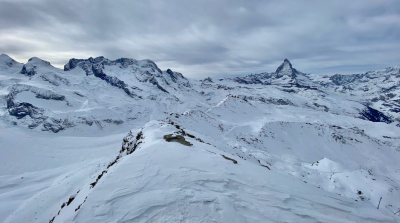
Zermatt, Switzerland. Image © PlanetSKI
On Monday morning PlanetSKI’s, Tashie Cove, who is currently in Les Gets in the Portes du Soleil in France woke up to fresh snow.
This was the view as she opened the curtains this morning:

Les Gets, France. Image c/o PlanetSKI
“It is always fantastic to throw open the curtains and see a bit of fresh snow,” said Tashie.
“I have been in Italy for the past few weeks and we have barely seen a flake so this is especially welcome.”
The forecast from Sunday from Weathertoski.co.uk predicted, “20-40cm of snow expected across many northern parts of the Alps tonight.”
It appeared.
There was also a bit of overnight snow in Crans-Montana in Switzerland.
PlanetSKI reporter, Justine Gosling, was in the resort on Sunday evening as the snow started.
More to follow…
Sunday 5th February
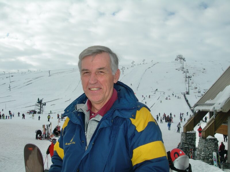
Our editor, James Cove, is in Switzerland today.
No prizes for guessing which resort.

James and family. Image © PlanetSKI
He travelled over for the day from Cervinia in Italy with his son Max and girlfriend Sally.
It is a €35 supplement to the Cervinia lift pass to ski in Zermatt and well worth it.
Not least for lunch.

Zermatt, Switzerland. Image © PlanetSKI

Zermatt, Switzerland. Image © PlanetSKI
Especially when the Irish waiter sang one song in between serving the guests.
All Zermatt regulars will know Dave.

Zermatt, Switzerland. Image © PlanetSKI
But what about the snow conditions we hear you ask?
“Here in Zermatt the on piste conditions in the Kleine Matterhorn area are superb. There is full covering and the cold temperatures have preserved the snow well,” said James.
‘There is good grippy snow, and it is excellent for some high-speed carving on the glacier and below.
“The White Pearl run was superb.
“Sadly there is no off piste to talk about and some of the steeper areas like Areloid in the Schwarzee sector that are skied by the experts need a decent amount before they can be skiable.”

Zermatt, Switzerland. Image © PlanetSKI
“Over in the Gornegrat area it is a similar story with great coverage on the main runs.”

Zermatt, Switzerland. Image © PlanetSKI
There is snow on all the runs down to the village.

Zermatt, Switzerland. Image © PlanetSKI
And on the roofs of the mountain restaurants.

Zermatt, Switzerland. Image © PlanetSKI
“In the middle of the afternoon strong winds came in and many of the higher lifts in the Kleine Matterhorn sector closed,” said James.
“We sped round to the area fearing the connection to Italy might close, but the new 3s Gondola was running in the high winds, albeit slowly.”
“We made it home this time.”
Why did he say this time?
Two years ago ahead of the pandemic it was a different story and he had to hike out to get back to Cervinia as the lift closed.
See here for his full report on the visit back in 2020 and the unplanned exit:

Zermatt to Cervinia. Image © PlanetSKI.

Zermatt to Cervinia. Image © PlanetSKI.
More to follow….
Saturday 5th February
James was in Pila, in the Aosta Valley in Italy, with his wife, Kisia, on Saturday.

PlanetSKI in Pila, Italy. Image © PlanetSKI
“The temperature has shot up here on the slopes and down in the town of Aosta it is a staggering 20c. It really is hard to believe it is early February,” said James.

Pila looking across the Aosta Valley, Italy. Image © PlanetSKI
“We haven’t seen any snow since the second week in January and we missed out on the last snow to hit the Alps.,” said Kisia.
“However the pistes are in surprisingly good condition and there is plenty of good grippy on-piste skiing to be had,” she added.

Pila, Italy. Image © PlanetSKI

Pila, Italy. Image © PlanetSKI
Off piste is not an option.

Pila, Italy. Image © PlanetSKI
On Sunday James is heading to Zermatt, so we will be updating later from Switzerland.

Pila, Italy. Image © PlanetSKI
Across the Alps the fine weather continues with the temperatures warming up.
One of our regular readers, Holger Gasler, has been out on the slopes of Kappl in the Tirol in Austria.
“2m of fresh snow here in the resort with few people around – what an amazing skiing day,” he said.

Kappl, Tirol, Austria. Image c/o Holger Gassler.

Kappl, Tirol, Austria. Image c/o Holger Gassler.

Kappl, Tirol, Austria. Image c/o Holger Gassler.

Kappl, Tirol, Austria. Image c/o Holger Gassler.
“However there is high avalanche risk and staying on the marked slopes is highly recommended,” Holger added.
The have been some avalanches after the fresh snow, with one that took the lives of 4 Swedish skiers and a mountain guide.
See here for that story on PlanetSKI:
PlanetSKI reporter, Justine Gosling, is in Crans-Montana, in Switzerland.
“The snow conditions are great, despite the lack of recent snowfall and high temperatures. 20-30cm of fresh snow fell on Wednesday which has freshened things up nicely.”
“Crans-Montana is south facing, so we have been bathed in sunshine under pure blue skies since the snow eased off.”

Crans-Montana, Switzerland. Image © PlanetSKI

Crans-Montana, Switzerland. Image © PlanetSKI
“The pistes are very well maintained, the snow is soft and coverage good. Only a couple of runs down into town are closed due to lack of snow.”
“It’s very warm and the avalanche risk was 3 yesterday. Even at the highest lift at 2,927 the temperature was 2 degrees yesterday, and 13 at the bottom of the slope in town.”

Crans-Montana, Switzerland. Image © PlanetSKI
“Even by 4pm, the mogals were only just starting to form on a couple of slopes – probably because the slopes are very quiet so it’s not being churned up.”

Crans-Montana, Switzerland. Image © PlanetSKI
“The quiet slopes are wonderful, although will obviously be busier at the weekend.”
Justine is in the resort for a snow-camp event, the AJ Bell Crans-Montana Marathon.
Snow-camp is charity which supports disadvantaged youth to participate in snow sports which also offers mental health support and leadership training.
See more about it here in an earlier preview article on PlanetSKI:
Snow-camp last ran the event in Courmayeur in 2020.

Snow-Camp AJ Bell Courmayeur Classic 2020 – photo © Pierre Lucianaz

Snow-Camp AJ Bell Courmayeur Classic 2020 – photo © Pierre Lucianaz

Snow-Camp AJ Bell Courmayeur Classic 2020 – photo © Pierre Lucianaz
A parallel event is the City Ski Championships which is a weekend event whereby teams can enjoy the resort and race slalom & parallel slalom ski races for prizes.

Justine Gosling
Do check back for Justine’s reports later…
Friday 4th February
It is a blue sky day across much of Alps on Friday.
The latest photos we have come from one of our regular readers, Martina Jamnig, from the Austria National Tourist Office.
She has been in Zell am Zee in Salzburgerland this week.

Zell am Zee, Austria. Image c/o Martina Jamnig.

Zell am Zee, Austria. Image c/o Martina Jamnig.

Zell am Zee, Austria. Image c/o Martina Jamnig.

Zell am Zee, Austria. Image c/o Martina Jamnig.
Here are a few images from St Anton in the Tirol – the area has seen some of the heaviest snowfall in the storms of this week.
Ein magischer Ort für Ruhesuchende.
📍Verwalltal in #stantonamarlberg
📷 Suggi – #arlberg #winterliebe #verwalltal #austria pic.twitter.com/tq8F5fPWm0— St. Anton am Arlberg (@StantonReview) February 4, 2022
Ischgl is posting some pictures away from the ski slopes.
“Over the last few days, between 50cm and 80cm of snow has fallen quite widely across the northern half of the Alps (roughly from the Jungfrau region eastwards), with well over 1 metre in a few favoured spots such as in the Glarus Alps of eastern Switzerland and the Vorarlberg region of western Austria,” said the alpine weahter expert, Fraser Wilkin from weathertoski.co.uk.
Currently there are no further falls of snow predicted in the next week or so.
More to follow…
Thursday 3rd February
Lets not forget further north in Scandinavia.
Norway to be precise.
We are keeping an eye on conditions in Norway as we are planning to be skiing there next month.
Right, what about the Alps where it has been chucking it down in places…
Wednesday 2nd February
Here’s what it currently looks like in St Anton in the Tirol in Austria that has seen some of the heaviest falls of snow:
… and the SN❄W goes on.
Tag someone and make their day!
📍#stantonamarlberg ❄2.❄2.2❄22#arlberg #snowconditions #winterliebe #snowfall #schnee #snow #austria 🇦🇹 pic.twitter.com/EBjEC9EhSl— St. Anton am Arlberg (@StantonReview) February 2, 2022
It’s a snowy scene in nearby Soelden in the Tirol too.

Soelden, Austria. Image c/o Katleen Johne.

Soelden, Austria. Image c/o Katleen Johne.
The snow though is bringing its problems with some resorts unable to be reached.
There is a ‘high’ risk of avalanche across the Tirol and other areas of Austria with the warning at Level 4 on a scale of 5.

Image c/o lawin.at
It is a similar situation in neighbouring Switzerland where large parts of the mountains are also under a Level 4 alert.

Image c/o slf.ch
“Fresh snow and a strong west to northwesterly wind have given rise to extensive snow drift accumulations on the northern flank of the Alps,” said the Swiss Institute for Snow and Avalanche Research.
It says an “increasing number of gliding avalanches are to be expected’ and warns that “high avalanche danger will be encountered over a large area.”
The storm is due to pass by Thursday with a rise in temperatures which should mean some superb skiing conditions, though the snow may get a bit heavy lower down.
The authorities are advising anyone venturing off piste to be correctly equipped and obey all the rules and regulations.
Our latest video snow report comes from the PlanetSKI editor, James Cove, who is in La Thuile in the Aosta Valley in Italy.
It hasn’t seen the snow, but it does have some high winds.
The winds have closed much of the resort of La Thuile with the lifts at the top of the resort shut, including all the links to La Rosiere in France.

La Thuile, Italy. Image © PlanetSKI

La Thuile, Italy. Image © PlanetSKI
“There was still plenty of skiing for a decent afternoon on the slopes,” said James.

La Thuile, Italy. Image © PlanetSKI
Tuesday 1st February
The forecast storm has arrived with some areas expected to get up to 1m of snow by the end of the week.
The heaviest snow is in eastern Switzerland and Austria where up to 1m is expected to fall across the week.
Some of the resorts in the Tirol in Austria are seeing the best of it.
Here’s St Anton:
Schneehöhe / Snow depth (total):
❄️ Valluga, 235cm
❄️ Galzig, 215 cm
❄️ St. Christoph, 155 cm
❄️ Rendl, 125 cm
❄️ Gampen, 105 cm
👉Das Wetter: https://t.co/4OCOVBVOSl#stantonamarlberg #arlberg #winterliebe #snow #snowconditions #schneefall pic.twitter.com/H4xc34Y3Ld— St. Anton am Arlberg (@StantonReview) February 1, 2022
And elsewhere in the Tirol:
There are also some ferocious gusts of wind.
One of our regular readers, Valais Dude, has posted this video from Switzerland:
Things getting a bit bouncy in the gondolas @verbier4Vallees today ! pic.twitter.com/cLDFWCJ7mU
— Valais Dude (@ValaisDude) January 31, 2022
There is a Level 4 risk of avalanche in some places, caused by the high levels of snow and the strong winds.
Resorts under Level 4 alert include Davos/Klosters and Flims/Laax.
Much of the rest of the Swiss Alps is under Level 3, which means there is ‘considerable’ risk of avalanches.
Here is the situation in Switzerland on Tuesday 1st February:

Image c/o slf.ch
There is a similar situation in Austria with some areas of the Tirol under Level 4.

Image c/o lawin.at
Skiers and snowboarders who venture off piste are urged to carry all the correct safety gear, know how to use it and exercise caution.
The alpine weather expert, Fraser Wilkin from weathertoski.co.uk, says there will be further falls this week with significant depths in places.
“On Tuesday, it will remain mostly cloudy across the northern Alps though the snow will ease for a time,” said Fraser.
“On Tuesday night, though, another set of active fronts will bring even heavier snow to the northern and north-eastern Alps, lasting through Wednesday, with another 30-60cm possible from about central Switzerland eastwards.
This means that some of the Alps (e.g. the Austrian Arlberg) will have accumulated well over 1m of fresh snow by Thursday morning.
“Once again, the snow will be lighter in the north-western Alps (e.g. Portes du Soleil, 3 Valleys), and patchy or non-existent in the southern Alps.”
Monday 31st January
One of our regular readers in Austria, Holger Gasler, was in Obergurgl at the weekend (see post from Sunday) and he has just sent us an update:
“Compact and perfectly groomed slopes, but due to the strong wind some lifts were closed in the resort,” said Holger.
“The snow depth is 35 to 140 cm, with fresh snow in the forecast from Monday and Tuesday, with up to 50 cm coming our way.
“There are hardly any people on the slopes and overall it is pleasant,” he added.

Obergurgl, Austria. Image c/o Holger Gassler

Obergurgl, Austria. Image c/o Holger Gassler

Obergurgl, Austria. Image c/o Holger Gassler
Over the weekend Austria announced a loosening of Covid-19 measures.
See here for further details:
In Italy PlanetSKI reporter, Ian Davis, has just arrived in the resort of Passo Tonale.
“The on piste conditions are good, recent winds have removed the loose snow but they are being kept really well considering the lack of recent natural snowfall,” said Ian.

Passo Tonale, Italy. Image © PlanetSKI

Passo Tonale, Italy. Image © PlanetSKI
“Hard packed snow but most runs still allow good edge grip.
“Off piste on the lower slopes has no snow outside of the pisted areas. Higher elevations has been wind blown and un-skiable in most areas.
“Winds are starting to build today and snowfall is forecast later this week,” Ian added.

Passo Tonale, Italy. Image © PlanetSKI
Passo Tonale is a resort little-known by many British skiers & snowboarders.
Ian will be reporting back in detail later this week on what the resort is like, and why it may be worth putting on your list of resorts to visit.
He has also sent us this video snow report. Fingers crossed the snow arrives while he is there:
More to follow…
Sunday 30th February
New snow forecast for this week will be welcomed many, but as always it remains to be seen how much will fall, and where.
Our latest video snow report comes from our editor, James Cove, who has been skiing in Pila in the Aosta Valley today.
Out on the slopes of Pila in the Aosta Valley more snow is undoubtedly needed.

Pila, Italy. Image © PlanetSKI
But weekend ski racing continued, and there were many thousands of people out enjoying the sun and the snow over the weekend.

Pila, Italy. Image © PlanetSKI
Here is the latest from the alpine weather expert, Fraser Wilkin at Weathertoski.co.uk
“The weather in the Alps has entered a more unsettled phase, with a lot of snow and wind expected across many northern parts of the Alps (particularly in the north-east) over the next few days, especially between Monday and Wednesday.
“By the end of Wednesday, as much as 60-80cm of new snow is expected above 1500m in some northern/north-eastern parts of the Alps, with the Austrian Arlberg (Lech/Zürs/St Anton) as likely as anywhere to see these kinds of totals.
“More generally, around 30-60cm of new snow is expected across the northern Alps, from about central Switzerland eastwards, with 10-30cm likely in the western Swiss Alps (e.g. Verbier, Wengen, Villars) and the northern French Alps (e.g. Tignes, Chamonix, Avoriaz).”
On Saturday in Gressoney PlanetSKI saw saw something we hadn’t seen for a while – a cloud or two in the sky.

Gressoney, Italy. Image © PlanetSKI
The slopes were in excellent condition considering it hasn’t snow for a few weeks.

Gressoney, Italy. Image © PlanetSKI
It is bare down to resort level but the slopes remain open.

Gressoney, Italy. Image © PlanetSKI
Things though seem set to change with some snow on the way to this part of the Alps.
The weather has already caused some problems at Chambery airport in France as people try to get in and out of their ski resort this weekend.
Heavy fog disrupted some flights on Saturday and up to 500 people had to sleep in emergency accommodation overnight.
The incident at Chambery and the impact to some passengers has been reported in the Manchester Evening News.
The exception to the lack of recent snow has been in Austria where up to 50cm has fallen in places this past week.
The storm has now passed and the fortunate ones are out enjoying the conditions, including one of our regular readers, Holger Gassler.
He has been on the slopes of Obergurgl.

Obergurgl, Austria. Image c/o Holger Gassler

Obergurgl, Austria. Image c/o Holger Gassler
More snow is set for Austria later this week, though it will be accompanies by high winds in places
For a flavour of what the weather has been like this past week check out our earlier snow resorts on PlanetSKI.
Updated: Friday 28th January
Our latest video snow report comes from our editor, James Cove, who is currently in La Rosiere, France.
Now it should also be pointed out that when there are single clouds over Mont Blanc/Monte Bianco and the Matterhorn/Cervino the locals say the weather is about to change.
“The mountain has it’s hat on,” is how the locals from the two areas put it.
Now it may be an old-wives-tale, but from our skiing in La Rosiere and neighbouring La Thuile today the two mountain beasts of the Alps had their hats on.

Mont Blanc/Monte Bianco. Image © PlanetSKI

Matterhorn/Cervino. Image © PlanetSKI
Fingers crossed.
Also we don’t know if this has anything to do with the weather, but today at the end of January we saw a strange site.
A forest fire high up in the mountains.
It was above the village of La Thuile in the Aosta Valley, Italy.

La Thuile, Italy. Image © PlanetSKI

La Thuile, Italy. Image © PlanetSKI
Helicopters were scrambled to try to bring the blaze under control.
One may expect mountain forest fires in the middle of summer, but not perhaps in the middle of winter.
More to follow…
Wednesday 26th January
The wall-to-wall sunshine continues across much of the Alps and it feels more like spring than the end of January.
PlanetSKI’s editor, James Cove, has been in the Italian resort of La Thuile in the Aosta Valley today.
It was +8c at the mid-station at mid-morning.
The avalanche risk is 1, the lowest level.
We will be writing a full length feature on PlanetSKI about La Thuile shortly – in the meantime you’ll just have to take James’s word for it.
He tends to know what he is talking about.
Or at least he likes to think he does.
And here is the view from the top as we crossed from La Thuile into La Rosiere.
We are looking across to Paradiski and its resorts of Les Arcs/La Plagne and beyond.
Sunshine all the way.
One of our readers, Neil Bradbury, has commented on the video over on the PlanetSKI Facebook page:
“Love sitting by the Fort there. Great views,” he said.
There is no fresh snow to talk about, but there is lunch on the restaurant terraces, soaking up a few rays and skiing on empty slopes that have pretty decent snow covering.

La Rosiere, France. Image © PlanetSKI

La Rosiere, France. Image © PlanetSKI

La Rosiere, France. Image © PlanetSKI
Elsewhere in the Alps it is a similar situation, with blue sky all the way.
A PlanetSKI team has been in Verbier, Switzerland.

Verbier, Switzerland. Image © PlanetSKI

Verbier, Switzerland. Image © PlanetSKI

Verbier, Switzerland. Image © PlanetSKI
“There is no off piste skiing here in Verbier, but the slopes are in surprisingly good condition considering it hasn’t snowed for a while,” said PlanetSKI reporter, Marie Taylor.
“We are whizzing round empty slopes on good, grippy snow with the sun out – what’s not to like?” she added.
And here we are on the slopes:
For the full details of the weather across the Alps, and the all-important forecast, here is the latest from Weathertoski.co.uk.
Latest thoughts on the weather and snow situation in the Alps: https://t.co/PGoKdcOhGN pic.twitter.com/2lgkAYq1Jq
— weathertoski (@weathertoski) January 26, 2022
More to follow…
Tuesday 25th January
The latest images and information come from PlanetSKI reporter, Vanessa Fisher, who is currently in Val Gardena in the Dolomites in Itay.
“Blue skies and incredible panoramas all the way,” said Vanessa.

The Dolomites, Italy. Image c/o Vanessa Fisher.

The Dolomites, Italy. Image c/o Vanessa Fisher.

The Dolomites, Italy. Image c/o Vanessa Fisher.

The Dolomites, Italy. Image c/o Vanessa Fisher.

Valtournenche, Italy. Image © PlanetSKI